Happy training and good luck!
Thursday, November 29, 2012
Inspiration
Most mountaineers and alpine climbers know and understand that mountaineering is type 2 fun. For those that have not heard this mentioned before, it means that its not fun until your objective is over and you are back in the comforts of civilization. Many times mountaineering just feels like downright suffering. Mountaineering involves, extreme physical exertion, poor often dangerous weather, mind numbingly boring logistics, and very few comforts. This is before factoring in the difficulty and commitment of the chosen route. Now I'm not going to get into what drives climbers too pursue this sport or how it can affect your life, thats a completely different discussion for another time. What I will bring up is that out of all those things I mentioned, only one can really be controlled by the participant and that is their physical fitness. When one is fit and has no nagging injuries, the whole experience can be made more enjoyable. I have a few friends who have some of these nagging issues and it really tests their mental toughness every trip. If you love the mountains as much as me, love them more, get in shape and work on fixing those nagging issues. Maybe the man in this video can inspire you.
Happy training and good luck!
Happy training and good luck!
Wednesday, November 28, 2012
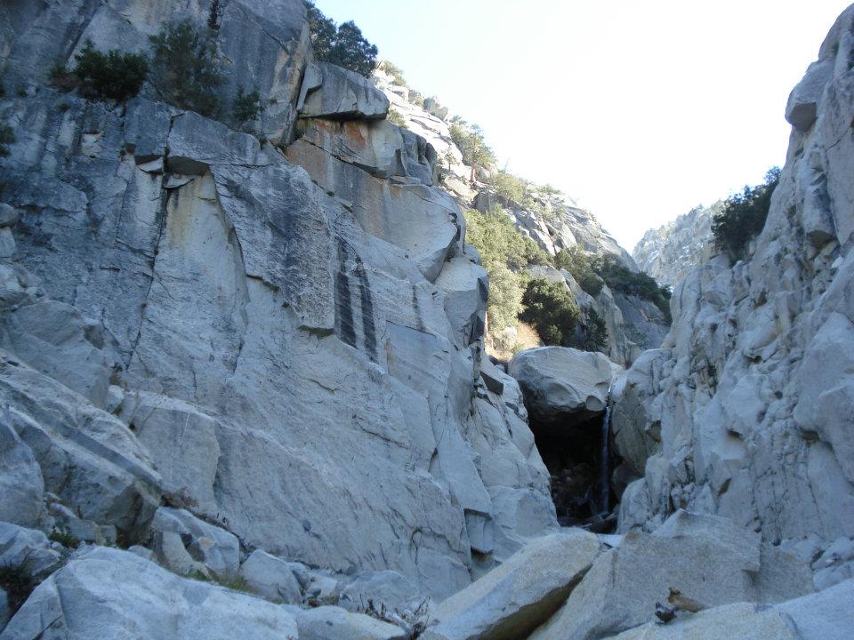
Bushwhacking, Rattlesnakes, Cold Food, and Free Soloing: A Snow Creek Adventure
Date Climbed: Early April 2012
Peak: Mt. San Jacinto (10,834')
Route: Snow Creek- Grade IV Class 4/5.7 WI 1 Moderate Snow
Gear: Helmet, Crampons, Ice Axe, (rope and a few nuts could be helpful)

Disclaimer (sort of):
This was one daunting climb. Plagued with access issues, poor snow, and difficult route finding, its not recommended for the beginner. With regards to access, be sure to research the Desert Water Agency's rules on the area. There is a one square mile plot of land that must be avoided. Lets keep this jewel open for others in the future.
To help train for our May trip to Mt. Rainier, Scott and I decided that the time was right for a trip up the Snow Creek route on Mt. San Jacinto. This route is by far the most difficult in Southern California, and easily one of the best alpine routes in the country. However, there is not much in the way of information about this route. There is no trail, there are hardly any cairns. This is a true mountain route that requires a complete knowledge of backcountry travel and route finding. Anyways. We drove from our home in Orange County out to Palm springs in the early morning hours. We arrived at the pullout of the road right at sunrise.
Twenty minutes later we set off across the desert unsure of where we were going and how long it would take us. We wove our way through the brush until we reached the base of the ridge that is used to skirt the private property. Just a few years ago, the common practice was to try and cross the private property in the early A.M. hours. Now you are guaranteed to be caught and fined. Climbing up the slope below the ridge was loose and complicated. There was a lot of shrubbery to be avoided and the threat of rattlesnakes always loomed in the back of our minds. We had read other trip reports where people had gained the ridge and taken it all the way passed the private land and then dropped back down into the drainage for a huge elevation loss. We decided to try and avoid that and just contour the slope just above the DWA land. The process was slow. Sometimes it would cliff out. In the end we found out that this way was more of a pain than we had hoped. We finally dropped back down to the left fork of the creek about a quarter mile after the waterfall.
The creek offered some welcomed shade from the desert sun, but our enjoyment was ended by the rattle of a very pissed off snake. Scott had disturbed him when he stepped over a fallen tree. I still had to make it passed this tree as well and there was no way around. I bit nervous and ran and jumped over it in hopes I would be moving to fast for the snake to strike. Luckily I succeeded. From then on we were very cautious of where we stepped and where we placed our hands. We scrambled up the other side of the creek onto this sort of plateau that is in between both forks of the creek. From here we thought we could see a faint use trail here and there, but it seemed to fade in and out. Every once in a while we would randomly stumble upon a cairn. Our technique was to just use the path of least resistance(more rock, less bushes). It seemed to do the trick because all of a sudden out of nowhere we came upon this tunnel through the shrubs. From a highpoint we realized that this seemed to be the only way through the dense vegetation without a machete. So we were lucky that we found it. By this time we had been in the hot desert sun for 5 hours and we were out of water. After the shrub tunnel, and some steep loose terrain, we found a small creek, and filled up our water bottles. From here the route stays left of the creek proper and continues up a small gully that looks like it will cliff out above the creek. Just keep going this is the right way. Scott and I were getting pretty beat down from all the bushwhacking, so when we crested the gully and found a small trail into the creek proper we felt a bit rejuvenated and relieved.
Once in Snow Creek itself the terrain depends solely on the amount of snowfall. If there is a lot of snow, the whole couloir can be filled with snow and avalanche debris. We were unfortunate and found there to be no snow at the start of the route. We boulder hopped up until we came to the Chockstone, a key marker on the route. In high snow years it can be completely covered. In our case it was completely dry and we had to take the 4th class ledges on the right. I could have sworn the top move was in the low 5th class range, especially in mountaineering boots and with a large pack. The use trail then takes you winding through small trees for a few hundred vertical feet. On the way through the trees, two climbers came down, one of them covered in blood. We asked what had happened and if they needed help. The hurt climber said that he was fine is was just a cut. Apparently they had gotten off route and climbed the wrong gully up a peaklet. Near the top of the peaklet it began to cliff out on them so they retreated and the climber fell and cut his hand. This made us pretty nervous. We wondered if we could find the right way. We wished them luck on the bushwhack back out and continued up through the trees. We exited the trees above a gully and were greeted with our first real glimpse of the route.
From there we tried to contemplate where the other two had gone wrong and tried to scope out the best route through the multiple steps. We descended into the gully and a few hundred feet up the creek later we found a nice flat spot to put our sleeping bags. While unpacking we realized that we had forgotten fuel for our stove. We couldn't believe it. A few weeks before we had forgotten a lighter on Whitney. (checklists are a good idea) We opted to rehydrate our food with cold water. It wasn't to cold outside so this was tolerable. We sat around and studied the map a bit more before we went to bed. It was still pretty early but the steepness of the canyon made it pretty dark.
The next morning we stayed in our sleeping bags till the sun rose and a faint amount of light entered the canyon. We packed everything up since we would not be coming back down the same way. Crampons, ice axe, and helmet ready to go, we began the climb. At first it was a mix of low angle snow and some boulder hopping. Then there was a short 10ft frozen waterfall, I would rate at WI1 or neglegable. We continued up some more snow and then we were hit with cliffs on all sides. We weren't sure what to do. The easiest way seemed to go the wrong way(this is where the other two got lost) We tried the next point of weakness. About 20 ft up we realized it was far to loose to safely climb so we backed down that as well. The only other viable option was a 25ft solid headwall. There was a small trough running up through it that looked like it could be climbed, but when we looked at it closely, it didn't look as easy. We decided to just climb the face itself. Luckily this could be done in two chunks. Scott went first and it didn't look easy. I handed him his pack and mine as well then I tried it. It was only 3 or 4 moves, but they were easily in the 5.7 range. It required smearing in bulky boots while only being able to grab sloppy oddly angled holds. Needless to say it scared the crap out of me. The second half wasn't as technical but it was just as scary since a fall would be very serious. Luckily we both made it to the top fine, and were relieved to see that it was snow the rest of the way.
Peak: Mt. San Jacinto (10,834')
Route: Snow Creek- Grade IV Class 4/5.7 WI 1 Moderate Snow
Gear: Helmet, Crampons, Ice Axe, (rope and a few nuts could be helpful)

Disclaimer (sort of):
This was one daunting climb. Plagued with access issues, poor snow, and difficult route finding, its not recommended for the beginner. With regards to access, be sure to research the Desert Water Agency's rules on the area. There is a one square mile plot of land that must be avoided. Lets keep this jewel open for others in the future.
 |
| A rough route |
 |
| Nervous |
 |
| The DWA land |
 |
| The left fork of Snow Creek |
 |
| Waterfall just above Scott's head |
 |
| The point of relief |
 |
| The Chockstone, 4th class terrain on right just out of frame |
 |
| Our glimpse of the route |
 |
| Scott at one of the first rock steps |
 |
| Scott just above the free solo |
 |
| Me just after the first fork |
 |
| Nearing the second fork |
 |
| Me headed up to the last fork |
 |
| The right of the left forks (there are two take the one on the right) |
 |
| The last few soggy feet |
 |
| Looking down the route |
 |
| Success! |
From that point the snow got steadily steeper. Nothing over 50 degrees though. The upper part of the mountain can be pretty confusing. The way I remember it is that at the first fork stay right, at the next fork stay right, and at the third go left. By the time we were almost near the top the snow had gotten super soft and the microwave effect from the canyon and the snow put the temperature around 90 degrees. We were cooking. We stopped once or twice in some shade to catch a break from the sun, but we knew the snow would just get more unstable. We pressed on and near the top we encountered the steepest climbing. In the loose snow it required all four limbs to get up it. We stood on top a few minutes later. We talked to a nice couple for a few minutes and they offered us some of their sandwiches which we accepted graciously even though I'm vegan and their ham and cheese wasn't. We could tell that they really wanted to help us and that they really didn't want their sandwiches. They took a picture for us and then we raced off down the main trail to get back to the tramway. On the way down we tried to make a b-line through the woods. Soon we got pretty worried that we might get lost because the forest was so dense and we couldn't see any landmarks that would be visible on the map. We decided to just continue in the same direction. Eventually we came upon some areas I recognized from when I came bouldering. In the end it only took us an hour or so to hike back to the tramway. Once at the bottom, Scott's dad was nice enough to pick us up and take us back to the car. At the end I checked my altimeter watch and it said that we had done a total of 13920 ft. of elevation gain over the two day climb. And according to the map it was roughly 20 miles of distance. "I think we are ready for Rainier."
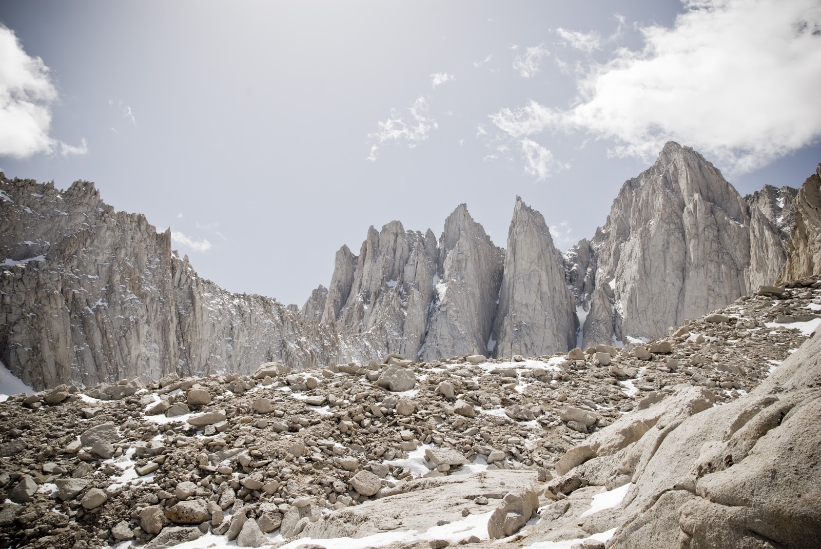
Mt. Whitney's Mountaineers Route: Five Years in the Making
Date Climbed: 4/29/2012
Peak: Mt. Whitney (14, 501')
Route: Mountaineers Route- Class 3/4
Gear: ice axe, crampons, helmet
The Route- Walk across the Iceberg Lake plateau to the base of the obvious couloir that is the Mountaineer's route.
Follow couloir to the notch and crest the notch and continue down 20 feet or so. From here you have a choice, the steepest class 3/4( best option in my opinion) immediately on your left, slightly less steep a few hundred feet further on the left, or the 3rd class option which contours to the west until the western slope is reached. The first is the most classic.
When I first got the itch to become a mountaineer, I stumbled upon a picture of Mt. Whitney and its Mountaineer's Route. Back then it looked impossible. The couloir shot straight out of the terrain and the route just disappeared behind the mountains east face. It was so aesthetically pleasing, even to someone with no experience whatsoever. This combined with Whitney's claim to fame, makes the Mountaineer's route one of the most popular routes in the world. I knew that I had to do it.
 It was not until 3 years later that I would get my first chance to try the route. A friend and I had just climbed the Baldy Bowl a week prior and we wanted something a bit more challenging so we set our sights on Whitney. It was the middle of December in the snowiest winter the Sierras have ever seen. Knowing of a recent 15 foot dump of snow the week prior we decided to test our luck. We drove up on a Thursday evening and parked at the usual road closure on the portal road. From there we hiked up the road with snowshoes, passing multiple cars trapped by the sudden storm. We finally decided to set up camp right on the road a few hundred yards ahead of the Whitney portal. That night it was cold. Really cold. The temperature in the tent got down to 3 degrees F. Both of us had frozen boots. It took us quite a while to get going in the cold. I could not seem to get my hands or my toes to warm up. By the time we started for the trailhead we were already defeated, and after a few hundred yards and deepening snow, we turned around and went down. We later found out that it was two weeks before someone broke through, but they still did not summit.
 My next chance to climb the route came in March of 2012. My friend Scott and had been training for Rainier. Scott had done the East Buttress of Whitney before and had no real interest in the Mountaineer's Route, but Rainier beckoned and we both needed the training. This time the snow was a non issue, 2012 was a terrible snow year in the Sierras. However when we got to our camp at Upper Boyscout Lake we realized that we had forgotten a source of fire for the stove. We went to bed hungry with cold water. The next morning we both felt a bit drained having not replenished our bodies. We both decided that a summit attempt was out of the question, but a quick 30 min. jaunt a bit higher to catch a view of the mountain was in order. After a viewing session we packed up and headed out, determined to return more prepared.
 It was a month later, on the verge of permitting season, that I finally had a successful attempt. Again, Scott and I, fresh off a successful ascent of Snow Creek on Mt. San Jacinto(by far more difficult), set off up the 395 at night, on the way to Lone Pine. We slept in our car the best we could, and lighter packed we set off the next morning. This time we decided it would be better to go all the way to Iceberg lake to have an easier summit day. This was fine with me, but Scott was worried since he suffers from debilitating altitude sickness occasionally.
In my infinite wisdom I chose to take a minimalist approach on this trip and only brought a 35 degree Mtn Hardwear UltraLamina and a +15 degree liner. The forecast was for 20 degrees. No surprise I was freezing all night even wearing all of my clothes. This wasn't the first time I had done this either. You would think I would learn. I guess a part of me likes the suffering. Well after a bad night sleep for both me and Scott, which more often than not is the case, we made some breakfast and then set off up the route about 30 min. after sunrise. The snow was decent at the start but was quickly softening in the morning sun. We hurried up the couloir which by this time of year was part rock part snow. It was not till the last quarter of the couloir that it was mostly all rock and dirt. We took a short break at the top of the notch to pack away ice axes and crampons and eat a bar. We then descended the 20 ft to the base of the top section. It was half rock and half snow/ice. There where two teams roped up. We had no rope. This worried us slightly but it appeared a route through the rock could be managed and we opted to go cramponless. We climbed some class 3/4 slabs dotted with ice to a nice ledge. Scott decided to throw the crampons back on for a short traverse across the snow. I decided to just take it really slow. It was pretty nerve racking walking across the small snow walkway with now crampons, looking down the north face to some lakes 3000ft below. I sucked it up and kept my balance and after 10 feet was safely to more class 3 rock. Once on the right side of this chute the climbing is pretty easy with maybe 1 or 2 class 4 moves. The snow and ice made it a bit more dicey but it was easily managed. Before we knew it were were at the top of the chute a few hundred yards from the summit.
We scrambled the class 2 talus to the true summit where we celebrated with a few photos and another small snack. For me it was great to finally climbed and summited something that had possessed my thoughts for so long. We decided to take the less technical class 3 contour back to the notch. This was actually very exposed in places and one slip would result in a desperate self arrest situation. Looked great for skiing though. Once back at the notch we quickly made our way down the deteriorating snow to our tent. Round trip tent to tent was in the 2 1/2 hour range. It took us another 4 hours to hike out. Great route. Next I'd like to try the East Buttress.
More Pictures:
Peak: Mt. Whitney (14, 501')
Route: Mountaineers Route- Class 3/4
Gear: ice axe, crampons, helmet
 |
| The Mountaineers Route |
A quick route description:
Approach- Starting at the Whitney Portal Trailhead, follow long sweeping switch backs to a sign near a small waterfall that marks the way to the Whitney Trail.
 |
| Turn north here |
Turn right up the hill and follow trail through dense trees. Once the trail comes out of the trees, there will be a large sandy clearing. look to the left for the trail to continue behind a fallen tree. This will then take you across to the south side of the creek. Stay on the south side of the creek(more pertinent in the winter) until the trail drops back down into the willows surrounding the creek. (In the winter it is also possible to stay on the south side of the creek all the way to Lower Boyscout). Once you cross the creek back to the north, turn west and follow through a tight clearing in the willows right up against the cliffs that make up the Ebersbacher Ledges. You will know when you are at the base of the ledges when you see obvious class 3 terrain in the form of boulders and steps. There is also an obvious tree about 50ft up the class 3. A lot of people may be nervous of what the ledges have to hold, but as long as you stay on route the exposure and difficulty are very low(there are no narrow ledge systems on route). The ledges soon turn into another winding trail system and before long you are at Lower Boyscout Lake.
 |
| On the talus above LBL
The lake offers some good camping options if you are not in a rush. Stay to the left side of the lake, the trail skirts the slope just above the lake and heads up through and obvious talus field to the southwest. Once at the top of the talus field follow the trail through the brush and onto the slabs. Once on the slabs follow the cairns all the way to Upper Boyscout (In the winter you can slog across the open field).
|
 |
| The shrubs on the way to the slab and UBL |
 |
| UBL and Mt. Russel in the background |
Upper Boyscout Lake also offers some camping options but not quite as many as Lower Boyscout and it seems the wind gets funneled though there from Mt. Russell. A better option in my opinion is to continue up the use trail to the south and follow it to a small rock outcrop on the left. The south side of this outcrop offers good flat wind protected ground to camp on. From here continue up the trail to near the base of Whitney's east face.
 |
| First peek of Whitney since the trailhead |
The cairns here are good and finding the way up to Iceberg Lake should not be an issue. Once at Iceberg Lake many options for camping exist though few are protected. This offers the best views of Whitney and in my opinion the best experience as well.
 |
| The Iceberg Plateau and Mt. Russell |
 |
| Midway up the main couloir |
When I first got the itch to become a mountaineer, I stumbled upon a picture of Mt. Whitney and its Mountaineer's Route. Back then it looked impossible. The couloir shot straight out of the terrain and the route just disappeared behind the mountains east face. It was so aesthetically pleasing, even to someone with no experience whatsoever. This combined with Whitney's claim to fame, makes the Mountaineer's route one of the most popular routes in the world. I knew that I had to do it.
 It was not until 3 years later that I would get my first chance to try the route. A friend and I had just climbed the Baldy Bowl a week prior and we wanted something a bit more challenging so we set our sights on Whitney. It was the middle of December in the snowiest winter the Sierras have ever seen. Knowing of a recent 15 foot dump of snow the week prior we decided to test our luck. We drove up on a Thursday evening and parked at the usual road closure on the portal road. From there we hiked up the road with snowshoes, passing multiple cars trapped by the sudden storm. We finally decided to set up camp right on the road a few hundred yards ahead of the Whitney portal. That night it was cold. Really cold. The temperature in the tent got down to 3 degrees F. Both of us had frozen boots. It took us quite a while to get going in the cold. I could not seem to get my hands or my toes to warm up. By the time we started for the trailhead we were already defeated, and after a few hundred yards and deepening snow, we turned around and went down. We later found out that it was two weeks before someone broke through, but they still did not summit.
 My next chance to climb the route came in March of 2012. My friend Scott and had been training for Rainier. Scott had done the East Buttress of Whitney before and had no real interest in the Mountaineer's Route, but Rainier beckoned and we both needed the training. This time the snow was a non issue, 2012 was a terrible snow year in the Sierras. However when we got to our camp at Upper Boyscout Lake we realized that we had forgotten a source of fire for the stove. We went to bed hungry with cold water. The next morning we both felt a bit drained having not replenished our bodies. We both decided that a summit attempt was out of the question, but a quick 30 min. jaunt a bit higher to catch a view of the mountain was in order. After a viewing session we packed up and headed out, determined to return more prepared.
 |
| Scott just after the trail split |

 |
| Mtn Harwear EV2 and Mt. Russell |
 |
| Scott taking a quick break mid way up the couloir |
 |
| Finally on the summit of Whitney(Russell looks tiny) |
 |
| The Iceberg Abyss |
 |
| LB Meadow |
 |
| Scott resting on talus field above LBL |
 |
| Water streaks above LBL |
 |
| UBL |
 |
| Crooks, Keeler, and Whitney |
 |
| Me in the couloir |
 |
| Scott enjoying the summit |
 |
| Looking north to Russell and Williamson |
 |
| Scotts Summit pic |
 |
| Headache |
 |
| Is this really the Sierras? |
Wednesday, December 14, 2011
To the Summit of the Western Hemisphere
Date Climbed: 11/16/2011-11/26/2011
Peak: Cerro Aconcagua (22841')
Route: Normal Route
Gear: no technical gear required

After boarding in Mexico City, my plane flew nonstop to Santiago, Chile were I caught a connecting flight to Mendoza. I would have loved to visit Santiago, but there is a $300 entrance fee for Americans, so I opted out. I landed in Mendoza at 8:30 am and proceeded to the hostel I had booked. The taxi driver that picked me up at the airport had no idea where the hostel was, but luckily I knew it was next to the bus terminal so I had him drop me off there. I strolled into the hostel and got my room key. I was so beat from my trip to Mexico and all of the travel, but I wanted to go get my permit situation taken care of. I set off into town looking for the tourist office. It wasn't difficult to find. However, you must pay for the permit at a separate site. Its a pay office, I can't really think of anything similar here in the US. Anyways, it took me a while to find this pay office, and then I had to wait in line for 45 minutes only to find out that they didn't accept credit cards. So then I set off to find an ATM, that took me another 30 or so minutes and by the time I returned to the pay office, there was another line. I finally got my receipt and took it back to the tourist office to receive my permit. Afterward I went back to the hostel and took a nap until Ruben arrived.
Ruben had said that he would land around 5 so around 5:15 pm I went out to the lobby to wait for him, to my surprise he was already there, trying to find where I was. After introductions we went back into our room and grabbed cameras and money for the rest of the day. I was starving and hadn't eaten since the plane so we went and grabbed a bite to eat. I had pizza, which is actually a normal food item in Mendoza, lots of Italian immigrants and descendants. After dinner, I shopped around at a few of the local climbing shops for some warmer gloves, I eventually decided to rent some instead of buy, since I knew nothing about the gear that they were selling. The gloves I chose to rent would end up being a mistake.
We got back to the hostel and began to organize our packs and bags for the mules to carry. We had to keep everything for one night in our packs which doesn't sound like a lot, but Ruben and I both had our own tents, and the gear we were carrying was heavy duty stuff. I think my pack was still in the 30-40 lbs range. After packing we took showers than went to sleep.
The next morning we woke up around 8 got everything packed up and walked to the bus station to catch the 10 am bus to Los Penitentes. The bus was super cheap, 26 pesos for two people, like 7 dollars. The bus was surprisingly very comfortable as well. Not as nice as the express bus in Mexico, but the seats were actually better. The bus ride took around 4 hours, but it was beautiful.
We arrived in Los Penitentes, a tiny ski town deep in the Argentinian Andes. The resort had a few hotels, and one ski lift. We went to our mule outfitter Fernando Grajales Expeditions and weighed our bags for the mules, 50 lbs limit per person. we were under that limit. We spoke with Fernando a bit and were asking him about the ski resort. He said that he used to work avalanche control there in the austral winter, but it hadn't snowed there in two years. Sort of depressing.

We arrived at Camp Confluencia (11300') about 2 hours later. We set up our tents and went around talking to some people. Two Australian climbers introduced themselves. They were brothers and neither one of them had climbed as high as Aconcagua before. They were there with a guide, who ended up helping me with my recurring stove situations, throughout my trip. We also met two British climbers, John and Heather. And a Canadian couple, Jarrett and Tania. We spoke some more to the Austrailians, Grant and James, and their guide Lucas informed us that the rangers were very behind in getting ready for the season, so there would be no public toilets available and no helicopter rescue. What was our $300 permit for? After sorting out my stove situation and talking with the other climbers I headed in to my tent for the night. The hike to base camp the next morning would prove to be the toughest day of the expedition in my opinion.
I slept amazing that night, probably the best I had ever slept in a tent. I woke up around 7 and tried to make pancakes, which failed miserably. I packed up a set off for base camp around 9, Ruben was running a bit slow and told me to go on ahead. No one told me that I had walked out of base camp the wrong way. It took me a bit of time and a hairy boulder hop across a raging creek to get back on the right trail. From that point on I was moving fast. I started passing a lot of people. Around half way I came to a creek crossing. It looked small so I tried to vault it with my trekking poles. I just barely made it to the other side, and I was in full squat, the weight of my backpack pulled me backwards into the water, and I was just narrowly able to keep most of my body and my camera out of the muddy water. My hands were really cold for a while, but the eventually warmed back up, and I just kept motoring. The majority of the distance between Confluencia and Plaza de Mulas is very flat. The majority of the 3000' of elevation gain is in the last few miles of a 12 mile stretch. Needless to say, I hit a wall pretty hard right below basecamp. I struggled to make it the last half mile. It ended up being the most taxing day of the trip.


Once I got to Canada at 16300' I found a nice tent site and buried my gear under some rocks. I talked with Jarrett and Tania a bit and picked up some trash from last season. And set off down the mountain to base camp. The next day I awoke and expected to need a rest day, but I was still feeling good, so I decided that I would move up to Canada and spend the night there. The weather was possibly going to turn bad later, but I figured it wouldn't be much different in base camp. This time I was a little lighter and ended up knocking about 30 minutes of my hike time to Canada. I set up my tent and anchored it down with rocks as best I could. I wish I would have anchored a little better, because while it didn't snow that night, the wind was horrendous. It must have been gusting at 50 mph, maybe more. Luckily I had brought earplugs for just such an event and I actually slept ok. Before, that windy night however, I ran into stove problems yet again and it took me over an hour to melt three and a half liters of water. After that I invited John and Heather into my tent to watch a climbing movie, which we all thought was funny, watching a climbing movie at 5000 meters. When I checked my tent in the morning it was not ok. Part of the pole that attaches to the tent itself had sheared off completely in the cold wind. I tried to crimp the pole with pliers to make it fit in the tent with no success, then John, my British neighbor, suggested I shove a tent stake up it. That worked great, and my tent was mended, for the time being.
That day still feeling great, I decided to port more equipment higher, to camp Nido de Condores. The trail from Canada to Nido was even more loose than the trail from base to Canada. And when I say trail, I really just mean a slightly worn path on a loose hillside, with no real directionality or logical purpose. I ended up just walking straight up the mountain in many spots. As I was hiking the weather started moving in. By the time I reached about 2/3 of the way to Nido, I was in and out of complete white outs. I decided that rather than get stranded and lost by going further, I just cached my things at Ex-camp Alaska and headed down. On my way down I ran into John, I told him where I had stashed my things and thought he would do the same. I got back down to Canada and escaped the blizzard in my tent. I read my book. Heather asked about John and I had told her that I thought he was just going to cache his stuff near mine and then come down, but it had been an hour or two and we couldn't see him. I kept an eye out for him and finally he appeared through the white mess. Turns out he made it all the way to Nido. Strong dude. The storm finally cleared around 6 pm. Ruben had come up and set up his things in the middle of it. We were all greeted with a spectacular sunset and amazing views.


That night the weather was calm and I slept really good again, despite being a bit cold. I checked the temp in the morning and it was 4 degrees in my tent. Once the sun came out and started to warm everything up, I began the daunting task of tearing down camp, packing up and heading up the mountain yet again. I still hadn't had a rest day. On the way to Nido I had to stop and pick up the stuff I had cached the day before. Now I was carrying a full pack, close to 55 lbs up to 18300 feet. It was brutally hard. My legs were so tired, and my back was starting to tighten up. I finally found Nido, but couldn't find a tent site that was protected from the wind. It seemed to be blowing from all directions. I ended up just picking a spot that seemed ok and had plenty of rocks for anchors. Setting up the tent in the wind was difficult though, it just kept blowing all over the place. The only way to set it up was to way it down with rocks, but that tears the fabric. Life is never easy at high altitude. After I got set up and took a break. Ruben had suggested wrapping my sleeping pad with my emergency blanket to reflect heat back at me. It ended up working great. John and Heather had been making me water since the night before since my stove was giving me so many problems. I was so grateful, but felt bad because I was worried I would cause them to run out of fuel. That night we had heard that the weather would be good for the next couple days so that raised our spirits. It was another windy night, only this time it was colder. I woke after sleeping for a few hours in a panic. I was gasping for air and was sweating. I felt abnormally hot, and my fingers and toes we oddly tingling. I started to assume the worst. I thought I was dying. I calmed myself a bit, and began to logically try to figure out what was wrong with me. I decided to take pictures of my fingers and my lips to make sure they were not blue from hypoxia. They were fine, red even. This gave me some relief, but I was still gasping every couple of breaths. I was able to fall back asleep though and when I woke the next morning I felt fine. It was a scary experience and it almost caused me to head down in the middle of the night.
The next morning however I learned that John had gone down. He woke in a similar panic to me and he was very sick. He did the right thing not continuing on. Heather decided to stick with me and Ruben. Heather, Ruben, and I discussed plans and logistics for the last camp and summit day. We had heard that there was a usable hut at Camp Berlin and we didn't want to deal with tents if we didn't have to, especially now that there were three of us. Heather and I decided to scout Camp Berlin for the hut, and take a small amount of food and gear up. Ruben stayed behind. He had cleared out the unoccupied rangers hut in Nido and slept in it the night before. I had him use my stove to make everyones water for the day since everyone had been making me water. It worked well in the little hut. Heather and I made it to Camp Berlin at 19500' in a short time. We caught up to two Czech climbers, they too were planning on staying in the hut, but the night before us. The hut was full of snow. Luckily there was a shovel. The Czechs and I took turns shoveling out the hut, no easy task at 6000 meters. It was dirty, but livable and would be much better than a tent. Heather and I left the Czechs and went back down to Nido. We spent the rest of the day hydrating and hanging out in the rangers hut.

That night Heather and Ruben spent the night in the hut, I retired to my tent. We were excited to be moving to Camp Berlin in the morning. The move to Berlin took a bit longer with the extra weight. Still we were all consistently beating the suggested hike durations from camp to camp, which gave us some confidence. The hut was nice. There was no wind, stoves worked, and for once I was actually with someone. We made water for summit day and cooked our dinners. Out of nowhere, one of the Czech climbers, Toni, comes into the hut. We were surprised because we had run into his partner when we arrived and he had said that Toni had gone down. Apparently he had actually summited, first one of the season. He was very tired and a bit out of it so we gave him some hot water and food. Once we had everything ready for summit day we turned out the lights and went to sleep, or tried.


It was unbelievably cold in the hut that night. I didn't check the thermometer, but I'm going to guess it was near -10. We woke around 6 am. Usually people start at 4, but we were fast and strong, and we wanted to wait for the sun to rise a bit more to warm everything up. We set off at 7. It was frigid. I wasn't wearing anything very warm. A few layers, but my plan was to go as light and as fast as possible. And I was fast. I had to leave Ruben and Heather, to maintain my pace and my warmth, but it wasn't long until my toes were totally frozen. I made the mistake of not starting with warm feet. Boots are insulators, they insulate cold feet and hot feet all the same. around 20000' I finally crested a ridge into the sun and I decided I wouldn't go any higher until my toes warmed up. I paced back and forth in the sun, scrunching my toes to try and boost circulation. Finally after about half and hour they were warm again, and Ruben had caught up. He told me that Heather had to turn around early cause she wasn't feeling right. We continued up together to Independencia hut at 21000'. I made the mistake of waiting there for Ruben, it chilled my body again and even though I warmed back up a bit, it was pretty much all over once we crested back over the ridge. The dark side of the mountain was much colder and directly in the wind. Ruben later checked the weather for that day and it said there was a wind chill of -40. We continued up the long slog called the Traverse toward a gully called the Canaleta.
From the Canaleta it was a few hundred feet to the summit. The wind was unbearable. Ruben was smart and brought a full face mask. I only had a balaclava that could cover my face, by I would have to sacrifice being able to breath easily. I resorted to trying to hide in the hood of my shell jacket. It worked ok. The real problem was that we were moving so slow now because of the wind that I could no longer warm my toes or my hands with my movement. We came upon a patch of snow, that had glazed over in the wind. Ruben stopped to put crampons on, but my hands were too cold to remove my gloves, and I felt confident in boot packing it. It was much icier than I anticipated and it turned out to be a very scary 100 feet of hiking. On the other side of the snow, there was no trail, it was somewhere underneath the ice. I had to try and climb up something I would compare to a hill of marbles. I began to get so frustrated and angry. I was so cold. I had lost full movement in my fingers, and my toes had lost feeling long before that. I finally made the unbearably hard decision to turn around. All my training couldn't prepare me for the cold, and like I said in the beginning, I rented the wrong gloves. The hardest part of turning around, was knowing I would have made it had it not been for the cold. I had no symptoms of AMS and was still doing 900 vertical feet an hour up to 21800' where I turned around. Ruben pushed on, with his warmer gloves and Polish badassness. I headed back down to Berlin, packed up, and headed to Nido. There I told Jarrett and Tania of my defeat. They encouraged me to go down to base camp. I wanted to, but I was so tired. I decided to take a rest and think about it. The thought of spending another cold night there, sent me down. I had no supplies and no drive left to make another summit push the next day. The weather the next day turned out to be perfect. Base camp was so warm. I found Heather there, she explained what happened. We spend the rest of the day playing cards. Ruben came down hours later in the dark successful. We all went to bed, totally spent.
The next day we high tailed it out of base camp. It took us a while to find a mule company that would give us a deal, but once we were on the trial we were on a mission to get the hell out of there. However, I took plenty of parting pictures.


The next day we all decided to get really touristy and go to Puenta del Inca just up the road. It is a really interesting natural bridge created by mineral springs. There was also a little market there with native wares. Some of the native wares were made in China though, so I was skeptical. After we visited Puenta del Inca we walked down to the Cemetario de los Andistes, the climbers' cemetery.


After the cemetery I had my first hitchhiking experience. We all hopped into this old 1960's Ford pickup. The driver was very nice, and we conversed with him as best we could in our broken spanish. He dropped us off at the hostel and we ate lunch. Ruben and I decided that we would grab our gear and head out that night on the 8 oclock bus. Heather was going to stay a few more days and wait for her boyfriend who had been climbing on the other side of the mountain. We said our goodbyes and waited for the bus.

Once back in Mendoza, Ruben and I got our fill of Argentinian steak, wine and beer, and the trip was over. I caught one last glimpse of Aconcagua from the plane. Not sure if ill be going back, but if I do, it will definitely be to climb a more substantial route, with warmer gloves obviously.
Total Elevation Gain over entire trip to Mexico and Argentina: 25300'

Peak: Cerro Aconcagua (22841')
Route: Normal Route
Gear: no technical gear required

After boarding in Mexico City, my plane flew nonstop to Santiago, Chile were I caught a connecting flight to Mendoza. I would have loved to visit Santiago, but there is a $300 entrance fee for Americans, so I opted out. I landed in Mendoza at 8:30 am and proceeded to the hostel I had booked. The taxi driver that picked me up at the airport had no idea where the hostel was, but luckily I knew it was next to the bus terminal so I had him drop me off there. I strolled into the hostel and got my room key. I was so beat from my trip to Mexico and all of the travel, but I wanted to go get my permit situation taken care of. I set off into town looking for the tourist office. It wasn't difficult to find. However, you must pay for the permit at a separate site. Its a pay office, I can't really think of anything similar here in the US. Anyways, it took me a while to find this pay office, and then I had to wait in line for 45 minutes only to find out that they didn't accept credit cards. So then I set off to find an ATM, that took me another 30 or so minutes and by the time I returned to the pay office, there was another line. I finally got my receipt and took it back to the tourist office to receive my permit. Afterward I went back to the hostel and took a nap until Ruben arrived.
Ruben had said that he would land around 5 so around 5:15 pm I went out to the lobby to wait for him, to my surprise he was already there, trying to find where I was. After introductions we went back into our room and grabbed cameras and money for the rest of the day. I was starving and hadn't eaten since the plane so we went and grabbed a bite to eat. I had pizza, which is actually a normal food item in Mendoza, lots of Italian immigrants and descendants. After dinner, I shopped around at a few of the local climbing shops for some warmer gloves, I eventually decided to rent some instead of buy, since I knew nothing about the gear that they were selling. The gloves I chose to rent would end up being a mistake.
 |
| Checking out the gloves at the gear shop- photo:Ruben Karel |
 |
| In the room organizing and copying the weather report- photo:Ruben Karel |
 |
| Bus station in Uspallata, the midway point. |
 |
| Our bus |
 |
| Los Andes from the bus ride |
 |
 |
| Inside Grajales- photo:Ruben Karel |
 |
| Lone ski lift and no snow |
 |
| Los Penitentes |
After squaring away everything with Grajales, they shuttled us to the trailhead and help get out permits signed by the rangers. It is common practice on Aconcagua to check in with the rangers at every station, but as we would soon find out, they weren't in full swing yet. We set off from the trailhead in the early afternoon. It was already really windy, but even at that altitude, 9500', it was still warm. The hike to Camp Confluencia was easy, 4 miles and about 1500' of total gain with all the ups and downs.
 |
| Ruben at the trailhead |
 |
| Ruben in front of Aconcagua and the Laguna de Horcones |
 |
| High spirits at the start |
 |
| Laguna de Horcones |
 |
| First stream crossing |
 |
| Jagged hills above Confluencia |

 |
| Almost to Camp Confluencia |
 |
| Aconcagua hiding in the clouds |
 |
| My tent at Confluencia |
 |
| Camp Confluencia-11300' |
 |
| Horcones Valley |
 |
| Piedra Blanca- looks red to me |
 |
| South summit of Aconcagua, nearly 10000' above |


 |
| Just below Plaza de Mulas |
When I arrived in Plaza de Mulas there didn't appear to be any rangers present so I just skipped checking in and went to find the Grajalas tent area. Somehow I missed the obvious sign and had to go ask another expedition for help. I found what seemed to be a nicely protected tent platform, it wasn't, but at least it was flat. I set up my tent and then everyone else began showing up. The long day with the heavy pack did a number on my back. It hurt so bad I had a hard time breathing. I thought I might need two rest days at base camp to recover.
 |
| Glacier above Plaza de Mulas |
 |
| "There's no-one here" |


The next morning I awoke to more stove problems. It just wouldn't stay lit. It took a good 30 minutes of lighting and re-lighting to finally boil some water for breakfast. I tried to make pancakes again to no avail. "Honestly who brings a griddle on backpacking trips?" I surprisingly felt really good and decided to port some equipment up to Camp Canada. The hike form base camp to Canada is about 2000' gain over a very short distance, on some really loose, nightmare scree. It felt really tough hiking to Canada, but I was still far under the suggested 4 hour climb time.
 |
| On the way to Camp Canada looking down at Plaza de Mulas |
That day still feeling great, I decided to port more equipment higher, to camp Nido de Condores. The trail from Canada to Nido was even more loose than the trail from base to Canada. And when I say trail, I really just mean a slightly worn path on a loose hillside, with no real directionality or logical purpose. I ended up just walking straight up the mountain in many spots. As I was hiking the weather started moving in. By the time I reached about 2/3 of the way to Nido, I was in and out of complete white outs. I decided that rather than get stranded and lost by going further, I just cached my things at Ex-camp Alaska and headed down. On my way down I ran into John, I told him where I had stashed my things and thought he would do the same. I got back down to Canada and escaped the blizzard in my tent. I read my book. Heather asked about John and I had told her that I thought he was just going to cache his stuff near mine and then come down, but it had been an hour or two and we couldn't see him. I kept an eye out for him and finally he appeared through the white mess. Turns out he made it all the way to Nido. Strong dude. The storm finally cleared around 6 pm. Ruben had come up and set up his things in the middle of it. We were all greeted with a spectacular sunset and amazing views.
 |
| Camp Canada-16300' |

 |
| Ruben and some Czech climbers |

 |
| Aconcagua making an appearance |
 |
| Don't know the name of this peak, but I found myself taking a lot of pictures of it. |

 |
| John at Canada- sorry for the blurryness |


 |
| The maze of paths to Nido |
The next morning however I learned that John had gone down. He woke in a similar panic to me and he was very sick. He did the right thing not continuing on. Heather decided to stick with me and Ruben. Heather, Ruben, and I discussed plans and logistics for the last camp and summit day. We had heard that there was a usable hut at Camp Berlin and we didn't want to deal with tents if we didn't have to, especially now that there were three of us. Heather and I decided to scout Camp Berlin for the hut, and take a small amount of food and gear up. Ruben stayed behind. He had cleared out the unoccupied rangers hut in Nido and slept in it the night before. I had him use my stove to make everyones water for the day since everyone had been making me water. It worked well in the little hut. Heather and I made it to Camp Berlin at 19500' in a short time. We caught up to two Czech climbers, they too were planning on staying in the hut, but the night before us. The hut was full of snow. Luckily there was a shovel. The Czechs and I took turns shoveling out the hut, no easy task at 6000 meters. It was dirty, but livable and would be much better than a tent. Heather and I left the Czechs and went back down to Nido. We spent the rest of the day hydrating and hanging out in the rangers hut.
 |
| Heather on the way to Camp Berlin |
 |
| Cerro Mercedario from Camp Berlin |
 |
| Toward Chile |

 |
| We went the wrong way |
 |
| The Summit from Berlin |
 |
| Windy summit from Nido |
 |
| Hanging out at the ranger hut-photo: Ruben Karel |
 |
| Lunch time-photo: Ruben Karel |
 |
| One of my favorites-photo: Ruben Karel |
 |
| Hut life |
 |
| Camp Berlin 19500' |

 |
| Berliner Hut |
 |
| Camp Nido from Berlin |


It was unbelievably cold in the hut that night. I didn't check the thermometer, but I'm going to guess it was near -10. We woke around 6 am. Usually people start at 4, but we were fast and strong, and we wanted to wait for the sun to rise a bit more to warm everything up. We set off at 7. It was frigid. I wasn't wearing anything very warm. A few layers, but my plan was to go as light and as fast as possible. And I was fast. I had to leave Ruben and Heather, to maintain my pace and my warmth, but it wasn't long until my toes were totally frozen. I made the mistake of not starting with warm feet. Boots are insulators, they insulate cold feet and hot feet all the same. around 20000' I finally crested a ridge into the sun and I decided I wouldn't go any higher until my toes warmed up. I paced back and forth in the sun, scrunching my toes to try and boost circulation. Finally after about half and hour they were warm again, and Ruben had caught up. He told me that Heather had to turn around early cause she wasn't feeling right. We continued up together to Independencia hut at 21000'. I made the mistake of waiting there for Ruben, it chilled my body again and even though I warmed back up a bit, it was pretty much all over once we crested back over the ridge. The dark side of the mountain was much colder and directly in the wind. Ruben later checked the weather for that day and it said there was a wind chill of -40. We continued up the long slog called the Traverse toward a gully called the Canaleta.
 |
| The Traverse |
 |
| View from the Canaleta courtesy of Ruben |
 |
| Ruben on the summit. Congrats man. |
 |
| Busier base camp |
 |
| Mules |
 |
| Ruben snacking on an unfortunate mule |

 |
| Last look toward base camp |


 |
| I think this river comes from Willy Wonka's Factory |

 |
| Cool sedimentary layers |
 |
| This valley was filled with Amazing colors |
 |
| Ruben last shot with the mountain. He was up there the day before. |
 |
| Best shot I could get of Ruben with his Polish flag |
Ruben and I went back to Los Penitentes and met up with Heather. We had to spend the night there because the mules wouldn't be bringing our things down till tomorrow. That was fine with me. the last thing I wanted to do was travel. The hostel was nice. The food was better. And we ate a lot of it. And best of all there was BEER.


 |
| The hostel |


 |
| In the market-photo:Ruben Karel |


After the cemetery I had my first hitchhiking experience. We all hopped into this old 1960's Ford pickup. The driver was very nice, and we conversed with him as best we could in our broken spanish. He dropped us off at the hostel and we ate lunch. Ruben and I decided that we would grab our gear and head out that night on the 8 oclock bus. Heather was going to stay a few more days and wait for her boyfriend who had been climbing on the other side of the mountain. We said our goodbyes and waited for the bus.

Total Elevation Gain over entire trip to Mexico and Argentina: 25300'

Subscribe to:
Posts (Atom)